
Low-lying areas of Lhuentse face twin risk of GLOF and artificial dam burst
Autsho town in Lhuntse faces the risks of glacial lake outburst flood (GLOF) from the source of Khomachhu and an outburst flood from an artificial dam formed by Tsatichhu.
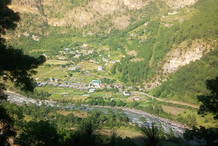
The town is located in the Kurichu basin at 868 metres above sea level and 85 metres from the river bank. It covers 200sq. metres and is populated by more than 1,000 people making up 72 households, including 14 shops and Autsho Central School.
Flood Hazard Assessment for Lhuntse Dzongkhag conducted by the Ministry of Works and Human Settlement in 2019 underlined Autsho’s vulnerability to flood as ‘the most critical and identified to need to produce hazard map’. The study recommended the creation of flood hazard maps for the settlement and update them regularly.
Threat from Tsatichhu artificial dam
The Tsatichu dam was formed in September 2003 when an entire hillside slid down and blocked the course of Tsatichu stream in Jaray Gewog. The dam is formed by 33 million cubic metres of debris. It is 1.4 sq. km, 113 metres deep and contains 12.5 million cubic metres of water.
The dam was initially thought to be stable but it partly burst on July 10, 2004, resulting in a massive flood. The flood submerged part of Autsho town with water level reaching up to the second floor of some houses. After the burst, the water level of the dam decreased by only five metres.
The chief geologist of the Department of Geology and Mines (DGM), Ugyen Wangda, said a heavy downpour that loosens the soil will cause in the wall of the dam to burst.
A field study carried out in May 2004 by a taskforce from the DGM alongside consultants from Kurichu Hydropower Project found that the landslide that formed the dam measured 2,354 metres on the top and 1,710 metres at the base.
A geologist from the DGM, Uygen Namdol, said that weathering of angular boulders and prolonged inundation coupled with saturation caused by extreme weather conditions would lead the dam wall to give way.
Another study carried out by the DGM on the stability of the Tsatichu dam from July 10-19, 2004, assessed the downstream hazard from the dam. The study found that heavy rainfall could feed supplementary inflows which would cause the water level to rise and burst the wall. The study warned of serious threat to settlements and infrastructure downstream.
Ugyen Namdol said an eventual Tsatichu dam failure could be similar to the cloud burst that occurred at Punatsangchu II, adding that the hillsides are made up of ‘graphitic phyllite rock’ or loosely structured rock which tends to crack and disintegrate at any irregular earth movement. In such an event, a huge landmass can fall into the dam leading to an outburst.
If the dam bursts, besides Autsho, the flood or, as the locals put it, the ‘wrath of waters’ could damage low-lying areas such as the farm road to Ladrong and Khuling, paddy fields in Rewan, and perennial landslide area of Rothpazhong.
Moreover, the Kurizampa bridge, which is about 8 metres above the water level, and Kurichu Hydropower are at serious risk.
However, Druk Green Power Corporation says it sees no risk to the hydropower project from the possible flood.
The Disaster Management Committee of Lhuntse Dzongkhag said that it had not monitored the dam since 2004 dam failure. But it has plans to monitor the dam.
Lhuntse Dzongda, Jambay Wangchuk, said that climate is unpredictable and the risk reduction methods for low-lying areas will be conducted based on research evidence.
Threat from GLOF
Autsho town and other low-lying areas in the Kurichhu basin also face risks from GLOF.
A study on re-assessment of glacial lakes in Bhutan piloted by National Centre for Hydrology and Meteorology (NCHM) in 2019 listed Terjatse Tsho as potentially dangerous. The lake feeds Khomachu, a major tributary of Kurichhu.
Terjatse Tsho is located at an elevation of 4,373 metres. The latest images show the lake has a surface area of 167,450 square metres. International Centre for Integrated Mountain Development (ICIMOD) reported 161,706.43 square metres surface area in 2001.
Glaciologist Karma Toep from NCHM said that Terjatse Tsho is potentially dangerous due to steep morphology at the outlet of the lake. An attempt at ground verification could not be successful due to avalanche.
ICIMOD in 2016 reported that the biggest climate-related threat in Bhutan was GLOF. The centre reported that Bhutan’s 24 weather stations showed a rise in temperature of about 1 degree Celcius in summer and 2°C in winter since 2000.
Bhutan Glacier Inventory 2018 by NCHM identified 90 glaciers covering 55.29 square km area in the headwaters of Kurichu described as the most dominant type of mountain glaciers in the basin.
In the event of a GLOF from Terjatse Tsho, besides Autsho and other low-lying areas downstream Kurichu, the flood could damage settlements by the banks of Khomachu such as Khomagang, Dhenchung, and Tsikhang.
Khomagang is located at 2,126 metres and 80 metres away from the bank of Khomachu. The village has eight households and experiences frequent flash floods due to extreme weather conditions in the mountains.
Dhenchung village is located at 2,292 metres and 50 metres from the river bank. Tsikhang Army outpost is around 500 metres upstream of Dhenchung and is about 45 metres from the river bank. Khomagang, Dhenchung, and Tsikhang are collectively known as Tsangno.
A severe flash flood in July 2011 damaged some swatches of land in Tsangno which will face the brunt of a GLOF.
Contributed by
Sonam Lhendup
This story is funded by Bhutan Media Foundation’s Climate Change Reporting Grant