

Choki Wangmo | Dagana
There is certain euphoria in travelling to new places. Lhamoidzingkha, as I saw on social media, was filled with colours and geological wonders.
I used to believe that the place was part of Phuentsholing being close to the border. It is also one of the oldest towns in the country in Dagana.
I heard that the town can be accessed from Gedu in Chukha. However, there is an alternate route along Dagapela-Dalbari road.
Until Gesarling in Dagana, it seems like one is travelling among human settlements. From there, the journey is long and ridden with risks. There are only a few clustered settlements. Otherwise, the endless winding road looks like a highway to uncertainty.
The secondary national highway that connects Dagapela to Dalbari in Lhamoidzingkha is still incomplete. There are four major bridge constructions that are in various phases of development. Some workers, who told me to drive quickly through a road that passes along a long cliff, said that the work would be completed by next month.
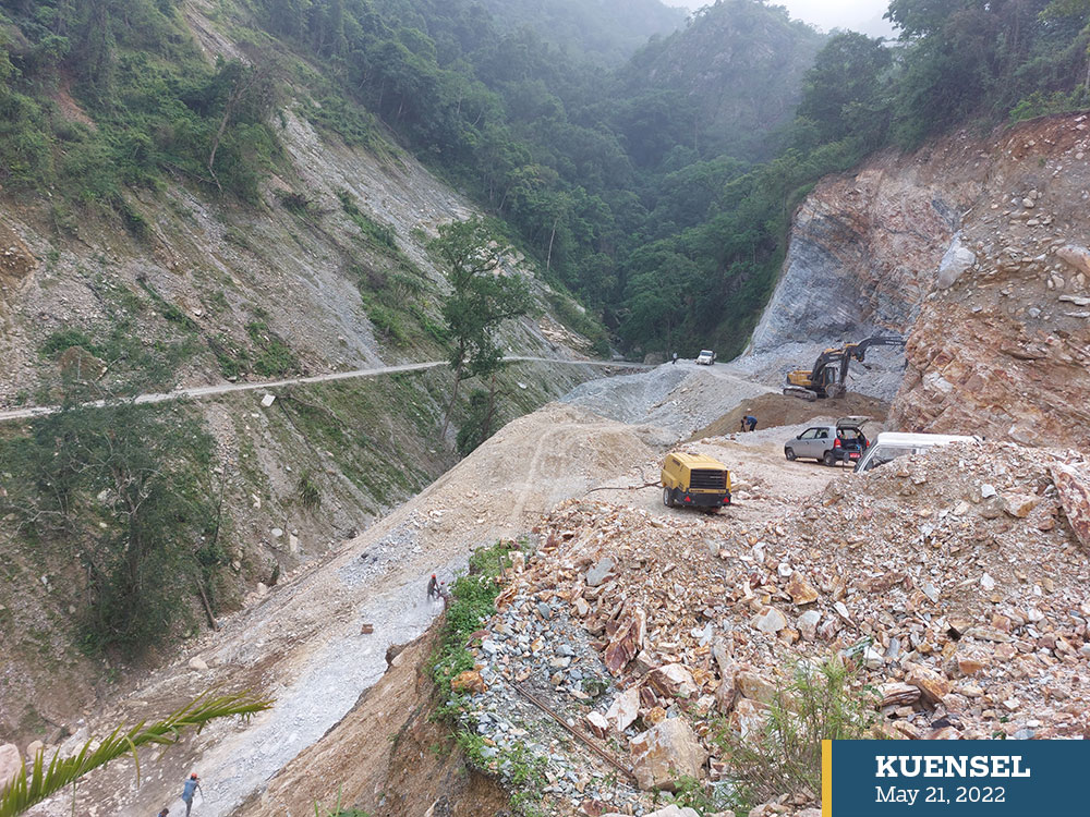

Scenes along the way
Till then, travellers have to drive through four streams that swell and are a risk during monsoon. A temporary bridge built over Samarchu was damaged from one end.
A few workers were there building side drains and clearing debris. Without proper drains, they said that the blacktop is quickly washed away by the heavy rain.
There are no vehicles plying on the road. I saw only a few Boleros on the way. The journey through tall, humid, and thick forests is silent. As fog rises through these trees, filling the air with earthy aroma, like that of a tilled soil.
If not for the wide and deep scars in certain stretches caused by excavation, one can feel what it means to live in one of the carbon negative countries in the world. At different locations, formidable ridges surround the place.
Although it is one of the most remote dzongkhags in the country, with the highest rate of poverty and alcoholism, Dagana is a virgin dzongkhag—one is bound to spot rare species in random—which some enthusiasts take years to catch a glimpse even.
A lone Rufuous-necked hornbill, a golden languar, and hordes of butterflies, for example.
The road passes amid the calls of various birds.
Settlements are not many. There are a few houses in the middle of thick forests—making one wonder about the status of human-wildlife conflict that is rampant in the region. There were rumours that the residents of Nichula gewog are looking for more resettlers with the hope that more humans would drive away wild animals.
The drungkhag is known for the increased incidents of conflict with elephants.
After passing Deorali, it is a steep descent. I had no sense of direction. I met a man on the roadside who told me that I was in Karmaling. Deorali stands on a hilltop.
There is a feeling of exuberance, like you are finally completing the 150-km-journey. The blacktopped road ends abruptly. There is a diversion without signboards. I took the road that appeared to be blacktopped but like looks can be deceiving, ended in potholes and cracks. I was on the wrong road—Karmaling gewog centre road.
The road to Lhamoidzingkha town is no better. It is not blacktopped and one has to drive on gravel. Before reaching the town, there are four streams to cross, each bigger than the other. The road is only for Boleros trucks.
The stream is differently coloured—purplish—almost. The pebbles are green, red, and purple. Lhamoidzingkha or Kalikhola, thus named after a female deity Palden Lhamo or Maha Kali, is considered to be blessed. There are different coloured ridges like a mandala at Lama Lamini and the deity’s lake.
After more than 4km drive, I reached Lhamoidzingkha town. Huge acres of areca nut orchards line by the roadside. The whole landscape is a “doma tshang”. The old town was dismantled and was in ruins.
Residents said that the town development was put to halt as the Sunkosh project might end their problems. The project never came and the residents are paying the price. They go without power for days.