
Glacial Lake Outburst Floods (GLOFs) mainly route through river channels often spreading out over wide flood plains. The river systems in Bhutan are composed of eight major rivers: Amochu, Wangchu, Phochu, Mochu, Chamkharchu, Mangdechu, Kurichu, and Drangmechu. Three rivers namely Amochu, Kurichu, and Drangmechu, are transboundary, they originate outside of the territory of Bhutan. The Amochu river originates from the Tibetan Autonomous Region (TAR) of China and flows through the western part of Bhutan (Haa and Samtse). The Kurichu also originates from TAR, but routes through eastern Bhutan (Mongar, Lhuentse). The Drangmechu river on the other hand originates partly from TAR and partly from Arunachal Pradesh, India, and flows through the eastern part of Bhutan (Tashigang, Tashi Yangtse).
The major river systems in Bhutan are mainly fed by glaciers and permafrost located in the high and cold Himalayas and Tibetan Plateau. Within the territory of Bhutan, there are approximately 1,583 glaciers, covering a total area of around 1,487 km2. While the area of permafrost and its contribution to the river systems in Bhutan is still unknown. In Bhutan, the glaciers have suffered area and mass loss since the 1960s. Unfortunately, studies have shown that the Bhutanese glaciers are likely to continue losing their mass under the current and future climate change scenarios.
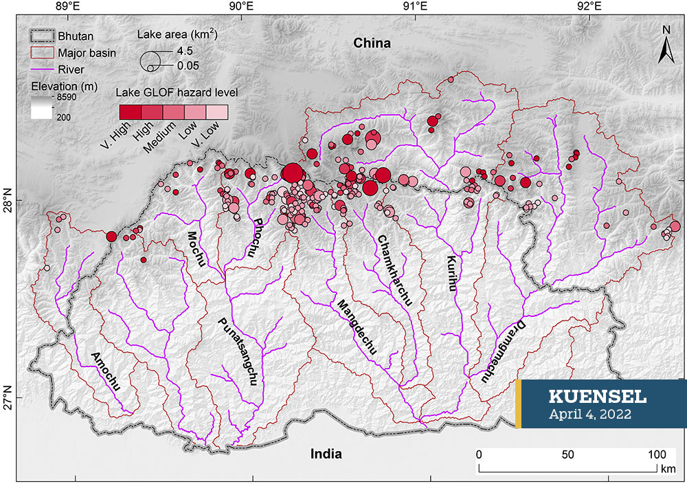
Continued mass loss of glaciers has resulted in the formation and expansion of glacial lakes. There are around 2,574 (bigger than 0.003 km2) glacial lakes in Bhutan as of 2020. However, not all glacial lakes are dangerous because some lakes are dammed by a stable moraine and surrounded by stable topography while some have smaller water volumes with a minimal downstream threat. The common and established baseline criteria used to identify dangerous glacial lakes are lake area (at least 0.05 km2), moraine composition, landslides, rockfall, avalanche, basin size, glacier activity, seismic activity, etc. Using some of these criteria, a recent study, published in the frontiers of Earth Science (Rinzin et al., 2021), has identified 278 dangerous glacial lakes in Bhutan, having a low to very high GLOF potential.
Alarmingly, Rinzin et al. (2021) has found that 84 of them were located outside of the territory of Bhutan, i.e., in the transboundary river basins – 50 in Kurichu, 30 in Drangmechu, and 4 in Amochu basins. These transboundary glacial lakes are serious threats because they provide both political and logistical challenges for field-based monitoring. In the case of an outburst flood, its impact can be felt several hundreds of km downstream. For example, the impact of the outburst of Lugge Tsho in 1994, which released about 17 million m3 of water (equivalent to a water volume enough to flood the entire Thimphu city by 0.7 m), was even felt at far-flung places in India, as far as 200 km away from the source of impact. Therefore, these transboundary lakes are potential threats to existing critical infrastructures such as the Kurichu hydropower plant, and planned projects like Kuri-Gongri and Amochu hydropower plants.
Although the high GLOF potential lakes within Bhutan are being continuously monitored by the National Centre for Hydrology and Meteorology (NCHM) using both annual field visits and remote sensing technologies, transboundary dangerous glacial lakes are possibly overlooked due to logistical challenges. Therefore, similar attention might be needed for the transboundary GLOF threats, at least by leveraging the currently available remote sensing technologies, owing to their rapidly growing sizes and overwhelming number. Moreover, infrastructure development and settlements are expanding along the mountainous river basins. Detailed upstream hazard and downstream risk assessments by incorporating different climate and GLOF scenarios are needed for identifying vulnerable downstream areas, disaster preparedness, and mitigation. Additionally, the installation of early warning systems and seismic stations close to the northern borders is desirable to monitor and mitigate transboundary GLOF threats.
Another alternative approach to monitoring the GLOF threat is to exploit the potential of earth observation satellites. A plethora of free satellite data allows large-scale monitoring of dangerous glacial lakes. For example, the Sentinel-1 SAR data has the capability to acquire data irrespective of day and night and cloud conditions every 6-12 days. An overwhelming and uninterrupted wealth of data is being generated by Sentinel-1 SAR satellites at no cost to users. The additional potential of Sentinel-1 SAR data is its ability to measure a millimeter-level ground motion by exploiting interferometry techniques. Such monitoring capability of dangerous glacial lakes has already been demonstrated for the Lunana area by Wangchuk et al. (2022), published in Remote Sensing of Environment (a highly acclaimed Remote Sensing journal). The use of a similar approach and technology is recommended for monitoring transboundary dangerous glacial lakes.
The article is published based on personal experiences and observations by a group of water researchers from Bhutan. The group can be contacted at waterresearchbhutan@gmail.com