
Yangyel Lhaden
When a group of trekkers lost their way along the Druk Path trek in August of last year, the search and rescue team rescued them by locating their mobile phone signals and asking them not to move, and to light a fire.
Trekkers will not face a similar problem once the National Land Commission (NLC) launches its web and mobile application called Druk One Map with Global Positioning System (GPS) navigation.
The NLC, in collaboration with the Tourism Council of Bhutan (TCB) and other relevant stakeholders, has geo-coded major trekking routes such as the Trans Bhutan Trail, a 430-kilometre trail that starts from Haa to Trashigang; the Druk Path (Paro to Thimphu); the Snow Man Trek ( Laya to Bumthang); the Nub Tshonapata trek; and the Dagala trek.
Officials said the application can be used both online and offline. “A user can download the entire trek route prior to trekking and use it in offline mode. It will show an overview of the entire trek route and show all information along the trek route. The resolution of the map is 1: 35,000 and one can zoom in and see the pictures in high resolution,” an official explained.
The NLC’s director, Tenzin Namgay, said that the objective of developing the web-based application is to provide information about the trek routes, which will guide trekkers to plan their treks better. “The conveniences the application provides is also expected to promote Bhutan as a tourist destination.”
He said that the offline feature was added because, in many pockets of the trekking routes, the internet is not accessible. “The application will also show campsites, viewpoints, cliffs, and changes in elevation.”
The application will not only feature trek routes but also show all basic amenities located along the trek routes such as the nearest toilet facilities, grocery stores, restaurants, and health care facilities.
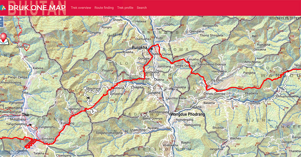
Geo-coded trek route with GPS navigation application can be used offline
The Nature Conservation Division has provided information on flora and fauna that can be found along the trek routes to the NLC that will be shown in the application.
Tenzin Namgay said that with navigation, the application will alert trekkers within what distance and elevation one can expect to see amenities, and which types.
Historical sites along the trek routes are also geo-coded in collaboration with the Department of Culture, where a user can click on the historical site and background of the significance of the sacred places.
In the next fiscal year, NLC would geo-code Singye Dzong in Lhuntse for GPS navigation.
Tenzin Namgay said that TCB recommended which trekking routes to survey and geo-code, as the main objective for the application was to be useful to trekkers. “It would be a waste of resources if we geo-code trek routes that are used less often.”
He said that if road alignment and information along the routes change, they will have to update the data by visiting the routes and updating the information with a GPS device. “The geospatial information policy requires all government agencies to work together to keep geospatial information up to date.”
Meanwhile, Druk One Map’s vision is to be a platform that provides single window access for citizens to access all spatial information related to geography.
Tenzin Namgay said that the NLC has been collecting spatial information over the last five years to produce guide maps, and the initiative to upload that information in a web-based application started last year. Information includes Nye Atlas, road networks, and boundaries for gewogs and chiwogs. “We will continue to produce hard copies as well as provide digital access to this information with Druk One Map.”
He said that although their priority was to geo-code trekking routes with GPS navigation with the application, the team will keep on working and collecting more information and uploading it to the application. “We will include a query system where a citizen can access all the spatial information of schools, land prices, and where the most suitable spaces are to construct hotels or institutions.”
The app will be launched next year.