
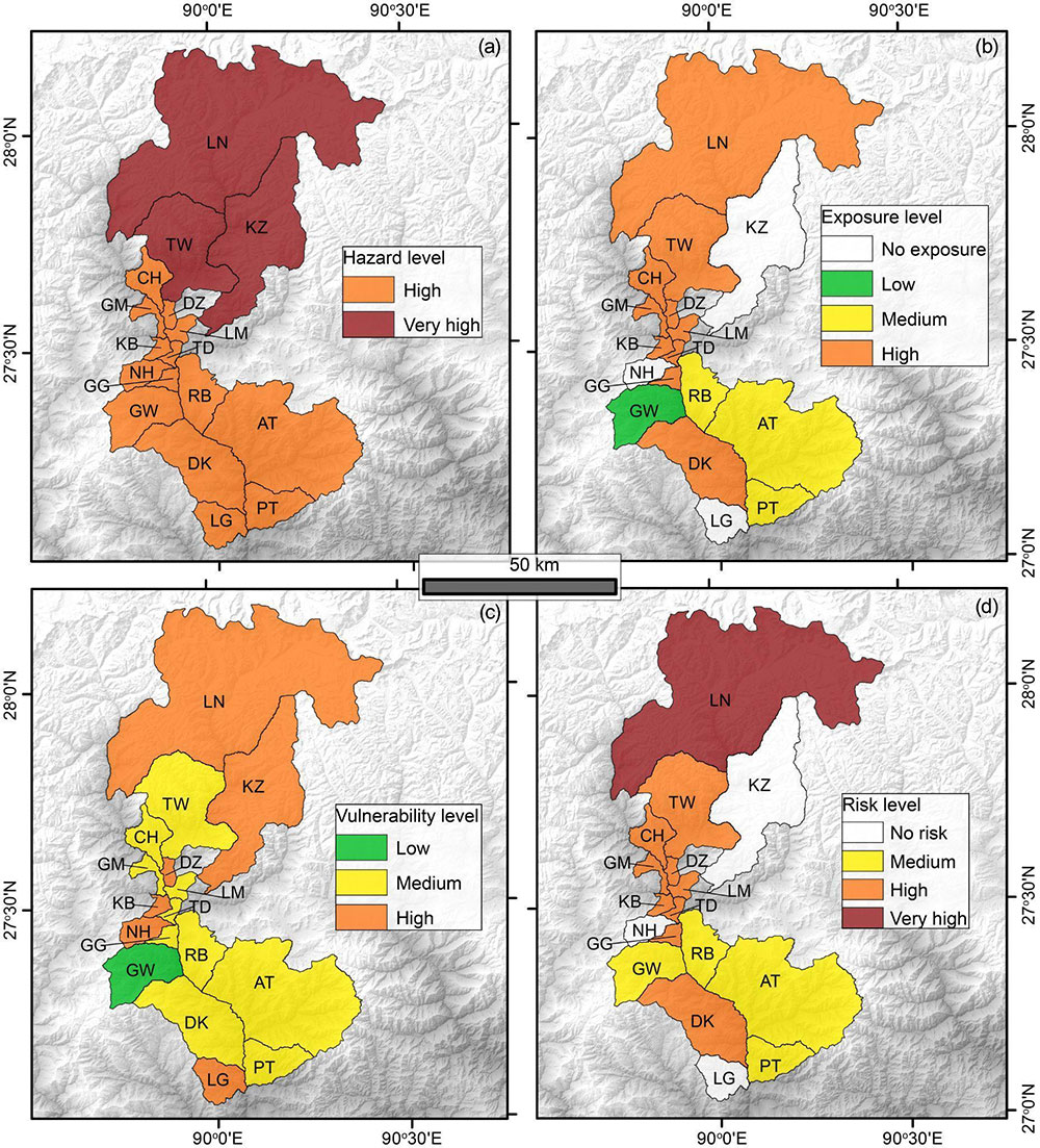
The figure shows the hazard (a), exposure (b), vulnerability (c), and risk (d) levels in 2020 of 17 gewogs downstream of the Lunana glacier complex under three different scenarios of GLOF magnitude (large, medium, and small) from each lake. The risk is calculated as a function of hazard, exposure, and vulnerability. The 17 gewogs are: Lunana (LN), Kazhi (KZ), Toedwang (TD), Chhubu (CH), Guma (GM), Dzomi (DZ), Lingmukha (LM), Kabisa (KB), Thedtsho (TD), Nahi (NH), Gase Tshogongm (GG), Gase Tshowongm (GW), Rubisa (RB), Darkar (DK), Athang (AT), Patshaling (PT), Largyab (LG).
Under the projected future deglaciating scenario, Bhutan along with surrounding regions in the Himalayas is identified as a future glacier lake outburst flood (GLOF) risk spot. In a recently published research, Rinzin et al. (2023) conducted an extensive assessment of GLOF hazards and risks in the Punatsangchu basin. The study evaluated the potential impacts of different moraine dam breaching scenarios of lakes in the Lunana glacier complex. By utilizing numerical models and integrating downstream structural and population data, the researchers were able to provide a comprehensive evaluation of the potential risks associated with GLOFs in the region.
The study revealed that four lakes, namely Bechung, Raphstreng, Thorthormi, and Lugge Tsho, could produce GLOFs with outflow flood volumes ranging between 6×10^5 and 3×10^8 m^3. These events could potentially impact over 16,000 people, 2,721 buildings, 6,157 livestock, 11.8 km^2 of agricultural land, 101.4 km of roads, 71 bridges, and two hydropower projects (PHP-I and PHP-II), up to 150 km downstream of the lakes.
Furthermore, the study revealed that the exposed elements at risk are primarily situated in the Punakha and Wangdue Phodrang districts, located at distances of about 90 and 100 km downstream of the Lunana glacial complex, respectively. Among the 17 gewogs within the basin, Lunana gewog was classified as a very high GLOF risk area, while nine gewogs including densely-populated areas such as Bajo and Khuruthang towns were classified as high GLOF risk zones.
This study highlights the importance of continuous monitoring of glacial lakes in the Lunana region and Bhutan as a whole, as well as the implementation of measures to mitigate GLOF risks. Therefore, a robust GLOF risk-reduction strategy including engineering measures, early-warning systems, and effective land use zoning are necessary to strengthen the local response capacity.
Developing and implementing the early warning system for GLOF risk reduction should include risk knowledge, monitoring and warning, dissemination and communication, and response capability. Assessing downstream GLOF risk involves evaluating flood hydrodynamic indicators generated from numerical modelling coupled with exposure of people and property and the vulnerability of elements at risk. Numerical hydrodynamic models like simple and straight forwards models like HEC-RAS can be used. The process of monitoring and warning for GLOF involves the deployment of specialized instruments and technical measurements to detect hazards, with the aim of issuing timely warnings to the affected population. It also requires proper protocol of disseminating and communicating warnings to the local people and leaders complying with national policy and local protocol.
For the relevant agencies and researchers, this recent publication titled ‘GLOF Hazard, Exposure, Vulnerability, and Risk Assessment of Potentially Dangerous Glacial Lakes in the Bhutan Himalaya’ by Rinzin et al. (2023), highlights the use of multi-source data in improving the knowledge of downstream GLOF risk and serves as a base for improving GLOF risk reduction strategies in high mountain regions of Bhutan.
The article is published based on personal experiences and observations by a group of water researchers from Bhutan. The group can be contacted at waterresearchbhutan@gmail.com