YK Poudel
With winter approaching, the country’s risk of forest fires is rising, requiring greater caution. To help anticipate and manage these risks, Forest Fire Exposure Index was launched yesterday. This open-source tool uses satellite data and AI to predict forest fire threats and strengthen climate resilience.
Government agencies, along with the Police and De-Suung, are closely monitoring the situation and preparing teams for quick response.
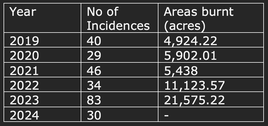
So far this year, Bhutan has recorded 30 forest fires, 58 house fires, and 28 other fire incidents, including vehicle fires, short circuits, and bush fires.
The Bhutan Forest Fire Exposure Index, developed by Geoneon, an AI-driven geospatial company, uses satellite imagery and predictive models to assess and manage forest fire risks. This pioneering open-source platform aims to strengthen Bhutan’s resilience to forest fires by providing advanced climate risk analysis.
Geoneon facilitators recently conducted a two-day training for 11 participants from key government departments and agencies.
Alexandre Bandini-Maeder, Geoneon’s chief technology officer, explained that the platform combines advanced geospatial technology with real-time data to assess fire severity and building exposure across Bhutan. “This tool helps government agencies, local authorities, and communities to prioritise safety, allocate resources effectively, and make informed decisions for fire prevention and resilience.”
The platform is designed to evolve, with plans to add new features, data layers, and resources. Eventually, Bhutanese agencies will be able to operate the tool independently and share results on their own platforms, ensuring its long-term sustainability.
The platform was piloted in Gelephu and Phuentsholing over a one-year period during its development. A participant noted that it would help response teams make more informed decisions about forest fire preparedness and response. “Access to updated data enables us to allocate resources more effectively, protecting both people and natural resources,” Alexandre Bandini-Maeder said.
Accessible at bhutan.geoneon.com, (See here) this platform empowers Bhutan to proactively tackle the rising threat of forest fires, intensified by climate change. The project, funded by the World Bank and administered by the Asian Disaster Preparedness Center, received a total of USD 225,000.
With 69.71 percent of the land under forest cover and 26 percent designated as protected areas, Bhutan’s rich biodiversity and communities are increasingly vulnerable to forest fires.
“This platform equips communities and agencies with actionable data, enabling data-driven strategies for preparedness and resilience to protect Bhutan’s natural and built environments,” said a participant.
Key features of the platform include a forest fire severity index, which factors in climate, vegetation, topography, and weather; a building exposure index, allowing communities and authorities to prioritize protective measures; and real-time data access to support timely responses during fire incidents.
Both the wildfire severity and exposure indices are based on the Geoneon Wildfire Data Stack, which integrates layers such as buildings, climate, vegetation, and topography to assess fire risks across the country.
According to the website, the Bhutan Forest Fire Exposure Index provides first responders with advanced tools for forest fire mitigation, using high-resolution mapping, algorithms, and comprehensive data to assess fire risks for buildings and communities.
The platform is designed to help government agencies, local authorities, and the public understand and address forest fire risks in practical and actionable ways,” according to the website.
Forest fires have been a persistent threat in Bhutan. In 2019, 40 fires burned 3,524.72 hectares; in 2020, 26 fires burned 2,387.14 hectares; in 2021, 43 fires burned 4,308.05 hectares; and in 2022, 34 fires burned 4,501.55 hectares. The situation worsened in 2023, with the country experiencing 83 fires—the highest number in the past decade—destroying 8,731.8 hectares of land.

How can this help the government?
By providing precise geospatial data, the Bhutan Forest Fire Exposure Index enables authorities to prioritize safety measures in high-risk areas, develop targeted strategies to protect communities and resources, and optimize resource allocation for vulnerable regions.
Beyond supporting government agencies, the index is a public resource, giving residents insights into their specific exposure to forest fires. Key benefits of the platform include improved mitigation strategies, community engagement, long-term resilience planning, informed investment, efficient resource allocation, and comprehensive risk assessment.
The platform was developed in collaboration with the Bhutan Department of Local Governance & Disaster Management, the Department of Forests and Park Services, and international partners.


