
Flash floods usually occur in a short period, often as a result of incessant rainfall saturating the ground and excess rainwater overflowing the natural or man-made river and stream embankments flooding river plains. Gathering information from media reports, the National Centre for Hydrology and Meteorology (NCMH) recorded more than 60 events of flash floods in Bhutan from 1968 to 2016.
Despite the significant potential risk from flash floods, there are no existing hydrologic models to predict localized flash floods other than large-scale river basin models e.g. Punatshang Chu and Chamkhar Chu basins.
One of the recent flood assessment models (2019) for Trashigang dzongkhag developed using interpolated HydroMet data from sparsely populated HydroMet stations limits our understanding of the local stream hydrology. Many of the past investments into flood mitigation measures have come at high financial costs with no long-term solutions as observed in the Trashi Yangtse and Trashigang towns. Part of the investments should have been in understanding the local stream hydrology and building predictive models.
This article presents 6-key steps for creating localised hydrologic models, which could serve as flood predictive models for towns like Trashi Yangtse and Trashigang.
Data acquisition through remote surveys
In Bhutan, some flash floods recur frequently in places like Trashigang and Trashi Yangtse. The relevant agencies need to catalogue these floods while watershed properties need to be collected, using freely available remote sensing data, digital elevation models (DEM), drone technology, and field survey; and may use freely available tools like QGIS. The properties include but are not limited to – watershed area, watershed geometry, drainage basin area, number of tributaries, elevation, slope, aspect, land cover type, soil type, landslide, amount of rainfall, and temperature. Remote sensing data can be either optical such as Landsat and radar such as Sentinel-1. The DEM can be SRTM, ASTER, ALOS-PALSAR DEM.
In addition, the properties of watersheds can be compared to past events and study their similarities and differences to better understand the underlying reasons. When enough watershed attributes and samples are collected, machine-learning models can be used to automate the identification or prediction of flash floods. Therefore, data collection using the best available resources is the first critical step in planning toward sustainable flash flood management.
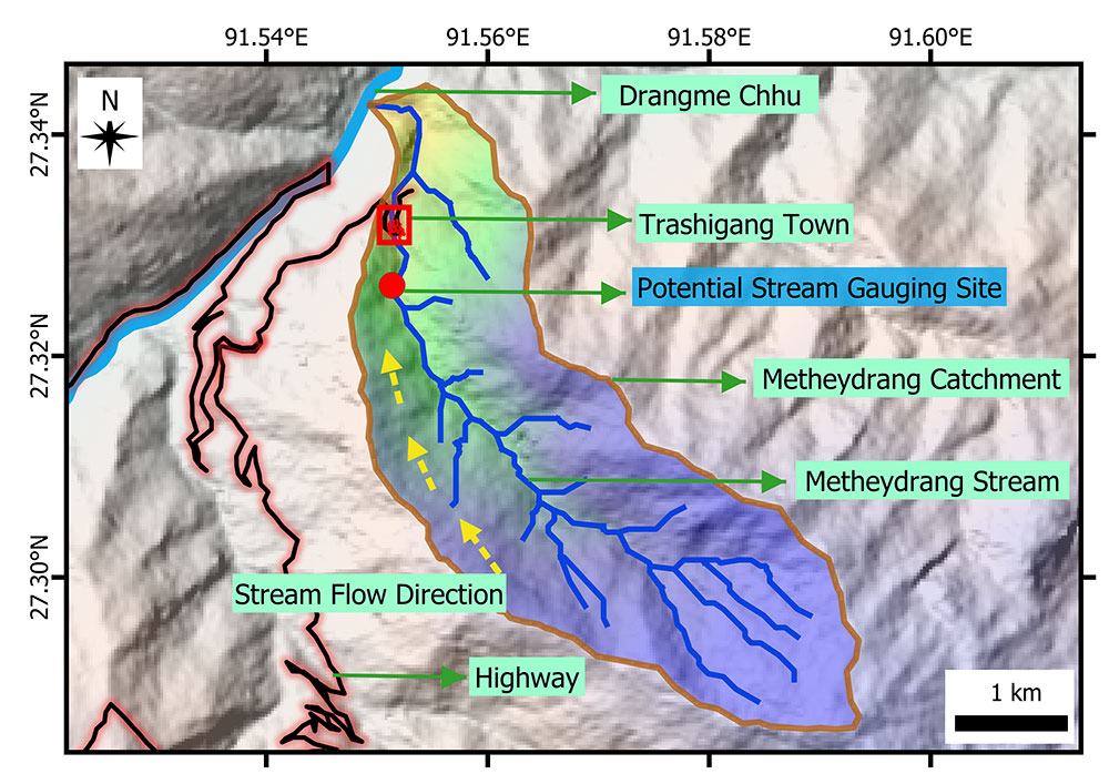
Field Observations
Long-term hydrological data collection apparatus needs to be set up for gathering hydrological data of the problematic stream/s. A gauging station can be set up at a suitable site where the outflow from the catchment can be measured with higher precision and accuracy (see pic).
The gauging station can range from simple staff gauges to highly accurate discharge measuring concrete structures. A rain-gauge/s needs to be installed to appropriately capture the variation in precipitation in the catchment. The gauging stations and rainfall gauging stations could all be automated using IoT-based data loggers, which can provide high-frequency data (maybe every 30 mins or hourly) for higher precision of the model.
Given the difficulties in collecting data, it can be tempting to use data collected from other basins or use data from regional gauging and HydroMet stations to model discharge. However, it is important to note that the use of the data collected from the stations beyond the catchment boundary may not appropriately represent the catchment under investigation as mentioned by the MoWHS report on flood assessment models (2019) for Trashigang dzongkhag. Thus, having a data collection station for each problematic catchment is necessary.
Modelling Water Discharge
The amount of water that is flowing through a river channel at a specific time and point is known as a river discharge. The discharge over time (typically in hours) is presented as a hydrograph, which shows the amount of water that is flowing from the catchment. For instance, river discharge increases during summer in Bhutan due to snow and glacier melt and rainstorm, while it decreases during winter due to less rainfall and frozen ice in the mountains. The amount of river discharge due to excess rainfall, which in turn causes flash floods, can be modelled using hydrologic models.
A few examples of free hydrological models are HEC-HMS and HBV-light Model. A predictive model for problematic streams could be developed for simulating different stream and river discharge scenarios. The complexity, performance, and accuracy of the model can vary based on an input data type and a scale of application.
The existing models have been developed in countries with sufficient data, and most of these models are applicable to plains and low hills. However, young mountains in the Himalayan region have complex hydrogeology, making it difficult to apply models directly to understanding the hydrological dynamics in Bhutan. Our recommendations are therefore to develop localized models using the data that are available and applicable to our environment.
Calibration of river discharge model
The models might produce unrealistic results due to some missing parameters or some other unknown factors. Thus checking the validity of the model using data collected from the field as mentioned above is critical. An advantage of using a calibrated model is that it can be used to simulate future stream flow responses accurately. Accumulation of discharge data over the long term would further improve the model’s confidence to accurately simulate future flood events. Therefore relevant agencies should start gathering data to feed into models that could be used for predicting flash floods. Developing localized models on all streams across Bhutan is impossible, but the focus should be on streams that have frequently flooded. As per the media reports compiled by NCHM from 1968 to 2016 the flash floods in four Dzongkhags – Chukha, Trashigang, Sarpang, and Trashi Yangtse, accounted for almost 60% of the total reported incidents.
Flood modelling
Once the discharge is modelled and calibrated as mentioned above, we can simulate floods of different intensities and generate hydraulic characteristics of rivers and streams such as peak discharge, flow depth, flow velocity, reach time and extent of inundation in the downstream community. This will provide first-hand information on the impacts of potential flooding on the lives of downstream communities. Moreover, the insights from modelling are highly useful for identifying the suitable location for installing early warning systems (EWS) and other mitigation activities. Such modelling can be done straightforwardly using freely available hydrodynamic models such as HEC-RAS and r.avaflow.
Preparation of flood risk maps
Flood models will be able to demarcate different levels of risk on the maps – low, high and very high risks. Areas prone to particular flash floods threshold events such as 30 years or 100-year events could also be identified along the floodplain.
Accordingly, people falling within the flood risk area must be educated and helped to build their resilience and response capacity through training and awareness programs. The flood hazard and risk maps must become an integral part of any mitigation and management activities supported by appropriate legislation. The risk maps however need regular updates depending on changes in the catchment properties and structural measures put in for flood mitigation.
We believe it is critical for the relevant agencies to start gathering hydrological data on problematic streams across the country and work towards developing localized models. Such models should then become a basis for the adoption of all kinds of flood mitigation and management strategies.
The article is published based on personal experiences and observations by a group of water researchers from Bhutan. The group can be contacted at waterresearchbhutan@gmail.com