
… but NCHM is bankrupt of funds and sensors
YK Poudel
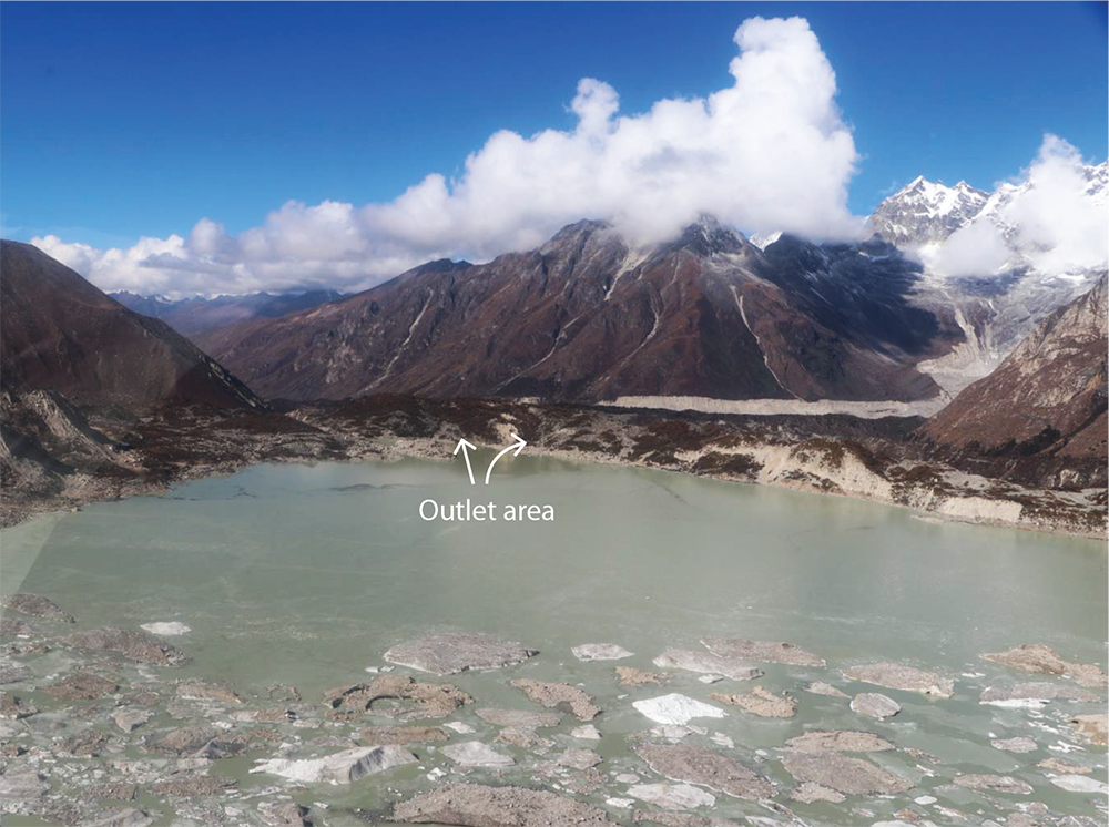
Thorthormi Lake and its surroundings remain vulnerable to flooding after the avalanche that made the lake flood on October 30, National Centre for Hydrology and Meteorology (NCHM) officials said.
As an immediate measure after the study of the Thorthormi Lake, the centre has strengthened monitoring at the source from once a week to three times a week. Thanza Automatic Water Level Sensor (AWLS) monitoring frequency has increased and damaged AWLS, installed in 2011, was repaired and is expected to last until April next year.
The centre is facing an acute deficit of necessary monitoring equipment.
The NCHM reported an increase in water level at Thanza Flood Monitoring Station at 7.41pm on October 30 from Thanza Flood Warning Station. Thorthormi Lake flooded at 7.20pm. A team of three experts from the centre was deployed to examine the conditions and assess the situation. The team conducted a drone survey of the area.
According to the experts rising temperatures could have caused the glacier above the lake to melt, causing an avalanche draining about two billion litres of water from the lake.
NCHM Director Karma Dupchu said that the Thorthormi Lake is disintegrated with ice exposed on the moraine dam at the main Thorthormi Lake outlet. “Thorthormi is no longer a glacier—Bhutan has minimum contribution towards it. As a collective effort, Bhutan must be funded for mitigation.”
The damage from glacial lake outbursts will go beyond Bhutan.
“The department is in immediate need of water level sensors, and ground vibration sensors, among others. We have put requisition for an emergency fund and equipment support in the 13th Five Year Plan—yet, witnessing the situation, there may not be enough time” he said.
Bhutan, according to the director, is not adequately prepared for the damage the next avalanche may cause. The NCHM as the nodal agency responsible for the generation of information and delivery of products and services on weather, climate, cryosphere and water resources, has been providing timely updates on BBS, mainstream media and social media on weather and related updates.
“Without much investment in monitoring centres and upgradation of equipment, an early warning system involving the local government leaders is the only measure we can take,” the director said.
With 289 stations across the country, the NCHM operates and maintains the national hydro-met observational network.
Betsho, Rapstreng, Thorthormi and Lugge Tsho—all four lakes in Lunana flow into Phochhu. So, any flood that occurs from any of the four lakes in Lunana will cause Phochhu to flood risking the lives of over 16,000 people, about 2,721 buildings, over 6,000 livestock, 11.8km square agricultural land, over 101.4km of road, 71 bridges, and two hydropower projects along the way, according to a study by Water Research Bhutan.
According to Bhutan Glacial Lake Inventory 2021, Bhutan records 567 glaciers covering 55.04Km square—Phochhu has the maximum.
Of the glaciers, 17 are potentially dangerous—Punatsangchhu has 11, Mangdechhu has 3, Chamkhar chhu has two and one in Kurichhu.